Home > Apps > Maps & Navigation > 2GIS: Offline map & navigation

2GIS is more than just a map; it's your ultimate navigation companion, offering offline maps, GPS navigation, live traffic updates, parking information, transit routes, and much more. Whether you're driving, walking, or using public transit, 2GIS ensures you'll never feel lost, even in unfamiliar territories.
With 2GIS, you can:
- Effortlessly locate addresses, businesses, phone numbers, operating hours, and find goods or services.
- Plan your route by car, bus, subway, or on foot, with turn-by-turn navigation.
- Find building entrances and nearby parking spots with ease.
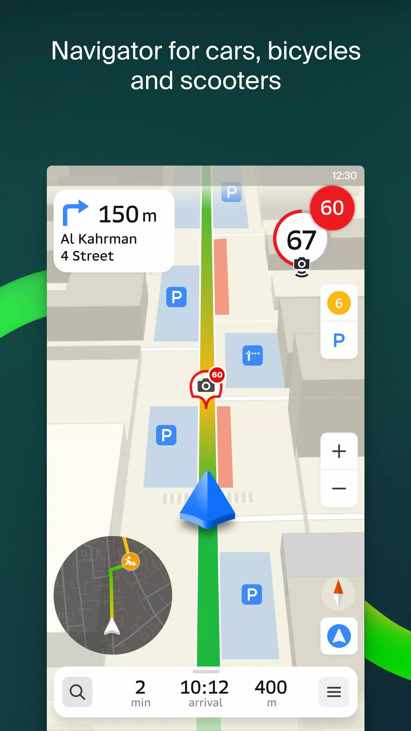
Our detailed maps pinpoint districts, buildings, streets, bus stops, subway stations, gas stations, sports facilities, and numerous other points of interest. With GPS navigation, you'll get real-time traffic updates, route suggestions that consider traffic jams, signs, speed cameras, toll roads, and unpaved routes. Our navigation even extends to intercity and multi-point journeys, and there's a free app tailored for Android Auto.
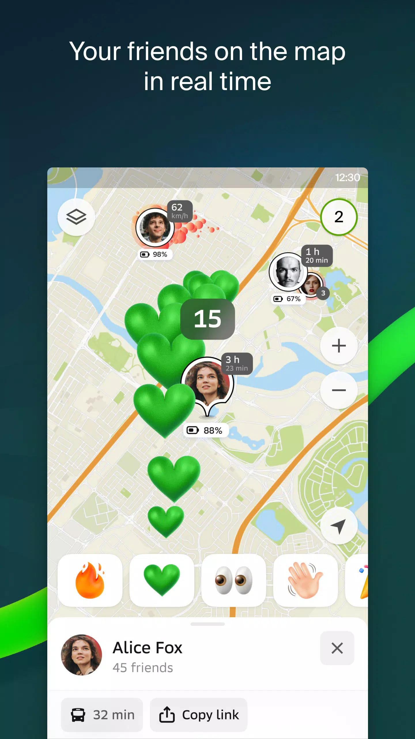
Stay connected with loved ones using the live friends' location feature. Track your kids or friends on the map for safety, send fun stickers, and monitor their device's battery life. You control who sees your location, making privacy management straightforward.
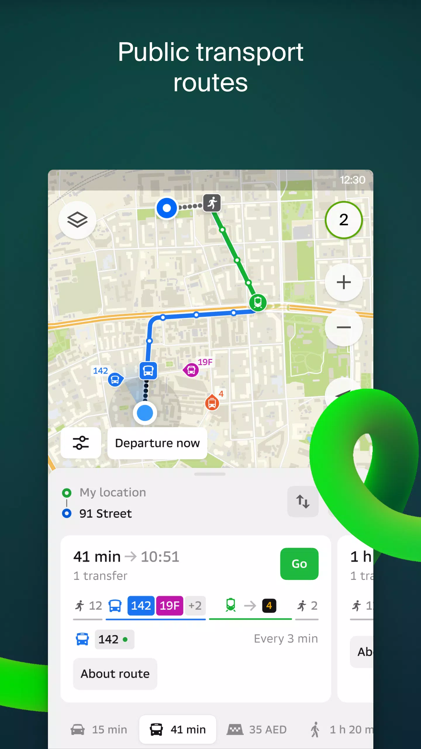
Keep informed with road event reports, including accidents, blocked streets, and speed camera locations, all displayed directly on the map. 2GIS also provides comprehensive public transport timetables and online routes, ensuring you're always on time.
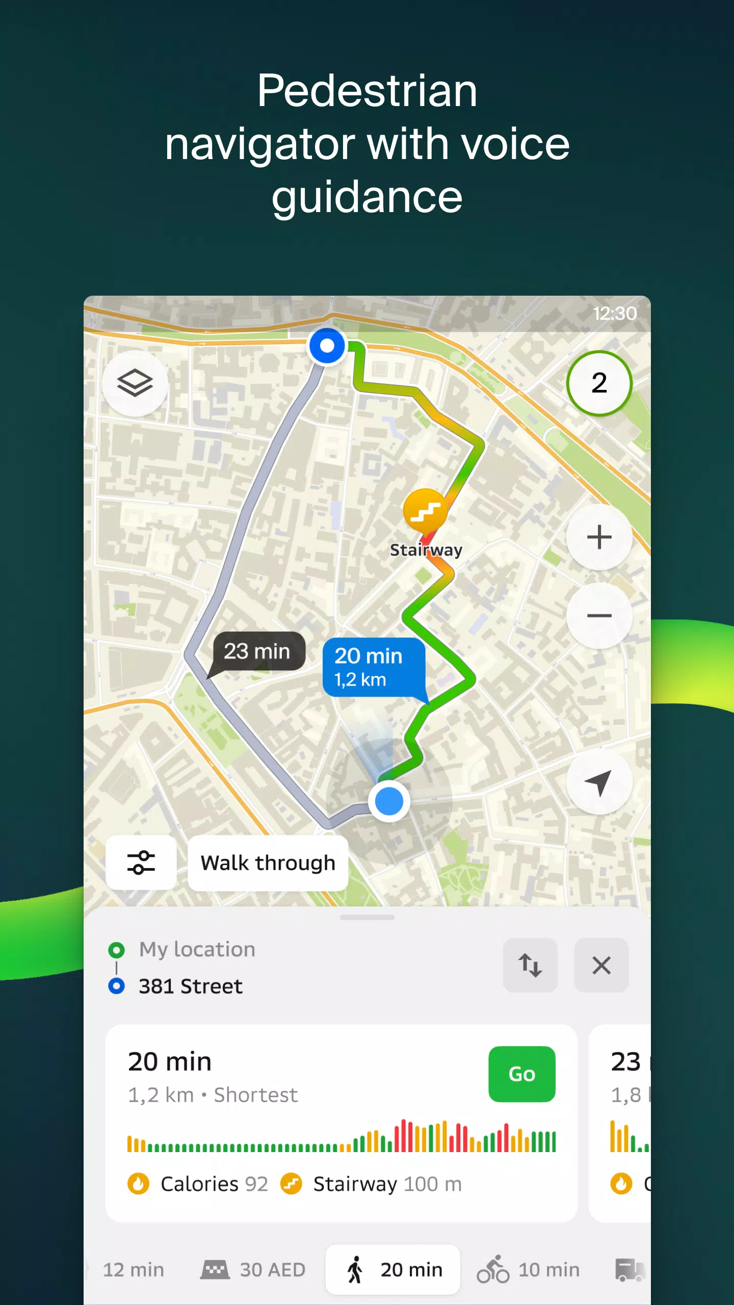
For pedestrians, 2GIS offers dedicated walking routes with voice guidance that works seamlessly in the background. Truck drivers can benefit from specialized navigation that accounts for vehicle and cargo specifics.
Our detailed directory goes beyond basic mapping, offering addresses, entrances, postal codes, phone numbers, operating hours, social media links, websites, and even user-submitted photos and reviews of businesses.
Explore new destinations with our travel guide, which highlights main attractions and Wi-Fi hotspots directly on the map.
For added convenience, the 2GIS Notifications companion app for Wear OS smartwatches lets you navigate routes on foot, by bike, or via public transport. With this app, you can view maps, receive maneuver hints, and get vibration alerts for turns or approaching bus stops. It starts automatically when you initiate navigation on your phone and is compatible with Wear OS 3.0 and later versions.
Available maps cover major cities in the UAE such as Dubai, Sharjah, Abu Dhabi, Al Ain, Ajam, Ras Al Khaimah, Fujairah, Umm Al Quwain, Dibba Al Fujairah, Khor Fakkan, Kalba, Al Salamh, and more. In Russia, 2GIS maps include Moscow, Saint Petersburg, Novosibirsk, Ekaterinburg, Krasnoyarsk, Chelyabinsk, Ufa, Omsk, Kazan, Perm, Nizhny Novgorod, Sheregesh, and others. Additionally, maps are available for cities in Belarus, Kazakhstan, Uzbekistan, Azerbaijan, and Kyrgyzstan, including Minsk, Pavlodar, Semey, Aktau, Aktobe, Almaty, Nur-Sultan, Bishkek, Karaganda, Kokshetau, Kostanay, Osh, Baku, and Tashkent, among others.
For support, you can reach us at [email protected].
Additional Game Information
Latest Version6.44.1.559.3 |
Category |
Requires AndroidAndroid 6.0+ |
Available on
|

2GIS: Offline map & navigation Screenshots


Top Download
More >


Trending apps
-

- Okuvaryum - Books for Kids
- 4.4 News & Magazines
- Okuvaryum: Digital Reading Platform for Kids!Okuvaryum is the ultimate digital reading platform for kids ages 4 and up. It offers a vast library of educational and entertaining children's books in Turkish, complete with beautiful illustrations and audio narration by voice actors. With new books added every month, Okuvaryum provides a fresh and engaging reading experience that helps children improve their listening, reading comprehension, and social skills.The app features a series format that helps young learners establish
-

- CheckMath
- 4.4 Productivity
- CheckMath: Your AI-Powered Learning Companion CheckMath, a free app leveraging cutting-edge AI and ChatGPT, is designed to revolutionize your learning experience. Need help with math, physics, or chemistry? Simply chat with our AI or snap a photo of your problem – any grade level, any subject. Get
-

- Loop Maker Pro: Dj Beat Maker
- 4 Tools
- Unleash your inner DJ with Loop Maker Pro! Create pro-quality beats and music with DJ loops and pads. Explore rock, EDM, and trap genres. Mix loops and pads for endless possibilities. Record your hits and share them with the world. Learn beat making skills with Loop Maker Academy. Experience the thrill of being a DJ with Loop Maker Pro!
-

-

- UCOO
- 3.5 Communication
- UCOO, a leading social networking app for Chinese-speaking users, fosters connections and builds communities. Its high-value matching feature pairs users with nearby friends, while the voice party function adds an auditory dimension to digital companionship. Tribal circles connect users based on shared interests and locations, offering both online engagement and in-person meetups. The tag matching system personalizes recommendations, ensuring compatible connections.
-

- Insmate Downloader:Story saver
- 4.5 Tools
- InsMate: Download and Share Instagram Content with EaseInsMate makes downloading and reposting Instagram content a breeze. Effortlessly save videos, photos, stories, and reels to your gallery without logging in. Share IG content with one click, including captions and hashtags. Enjoy offline viewing of stories and high-quality downloads. InsMate's user-friendly interface and reliable service make it the ultimate Instagram companion.
Latest APP
-

- 台北捷運Go
- 4.0 Maps & Navigation
- The "Taipei MRT Go" app has undergone a significant update, now offering a seamless integration with comprehensive traffic information. This revision includes direct access to webpages for Taoyuan International Airport MRT, Kaohsiung MRT, High-Speed Rail, Taiwan Railway, Maokong Gondola, as well as
-

- Crawfisher LE
- 4.4 Maps & Navigation
- GPS Navigation and Trap Management App for Crawfish/Spiny Lobster FishingDesigned specifically for Crawfish/Spiny lobster fishing, this app enhances your fishing experience by aiding in the recording of trap/condo locations and navigating to these spots efficiently.Features Include:Adding Trap Locat
-

- emmy: electric moped sharing
- 3.4 Maps & Navigation
- Moped rental and motosharing, rent a motorbike and hit the road.Join the emmy community and explore the city with our shared electric mopeds. The emmy scooter is always nearby, ready to take you anywhere easily and quickly.emmy offers electric moped sharing in five cities in Germany - Berlin, Dresde
-

- Trafi
- 2.0 Maps & Navigation
- Discover the ultimate mobility solution with the Trafi app, designed to streamline your transportation needs across multiple options. Here's how Trafi enhances your travel experience:Effortless Route Planning: Utilize our Route Search feature to find the most efficient public transport options tailo
-

- BP Fatár
- 3.8 Maps & Navigation
- Discover the official tree and park cadastral application of FőKERT with the BP Fatár application. This comprehensive tool allows you to explore the public tree and park cadastre of FőKERT along with additional district municipality cadastres including I., VI., X., XI., XIII., XIV., and XVIII. distr
-

- Taon Delivery para Entregador
- 4.0 Maps & Navigation
- Experience the ease, speed, and safety that our application offers to drivers in northern Paraná. Our platform is designed to streamline the process of receiving new rides, helping drivers boost their daily earnings efficiently. In case of any emergencies, you can quickly reach out to the establishm
-
- Live Earth Maps & Navigation
- 3.0 Maps & Navigation
- Discover iconic global landmarks and stay ahead with real-time traffic updates using Live Earth Map & Navigation. This app leverages live street mapping technology to provide panoramic views of your location, offering a detailed street view and an up-to-date traffic overview across the globe. Specif
-
- GO Sharing
- 2.0 Maps & Navigation
- GO Sharing by BinBin revolutionizes urban mobility with its eco-friendly e-scooter and e-moped rental services. With just one app, you have access to thousands of vehicles ready to enhance your daily commute or leisurely outings. Whether you're heading to work, enjoying a beach stroll with friends,
-
- BlueFire Apps
- 2.8 Maps & Navigation
- BlueFire Apps is designed to enhance the experience for truck, yacht, motorhome, and other vehicle owners by providing a range of advanced features. The app connects seamlessly to your vehicle through the BlueFire Data Adapter, which you can easily purchase from Amazon or directly from our store at
Breaking News
-

Emoak launches its latest casual puzzle game, now available on mobile platforms
-

-

No Snooze? You Lose! SF6 Tournament “Sleep Fighter” Requires You to Rest
-

Stumble Guys joins hands with My Hero Academia, heroic adventures are waiting for you!
-

Fortnite Re-Releases Paradigm Skin By Accident, Lets Players Keep It Anyways
-
Discover the Ten Dominating Cards in LUDUS: PvP Arena's Battle Royale