Home > Apps > Photography > VTI SkyTracker Ⅱ
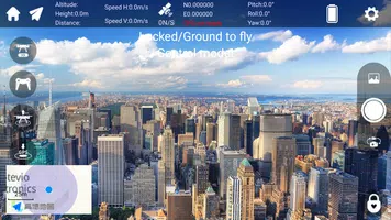
The VTI SkyTracker II is an advanced software solution tailored for professionals engaged in agriculture, environmental monitoring, and aerial surveying. This tool is essential for those who need to track, manage, and analyze aerial imagery and data collected from drones or other aerial platforms. With its robust capabilities, VTI SkyTracker II enhances decision-making by providing detailed insights and visualizations from aerial data.
Features of VTI SkyTracker II:
❤ High-Quality Data Analysis: VTI SkyTracker II supports high-resolution imagery analysis, ensuring that users can make the most out of their aerial data. The software processes data to provide clear and actionable insights.
❤ Real-Time Tracking: The software offers real-time tracking of drones, allowing for immediate monitoring and adjustments during flights. This feature is crucial for dynamic environments where conditions can change rapidly.
❤ Seamless Data Integration: Users can integrate data from various sources, making it easier to combine different types of aerial data for comprehensive analysis. This integration aids in creating a holistic view of the surveyed area.
❤ User-Friendly Interface: Designed with the user in mind, the interface of VTI SkyTracker II is intuitive, enabling users to navigate through the software effortlessly and utilize its powerful features without a steep learning curve.
FAQs:
❤ Is VTI SkyTracker II suitable for beginners?
- Yes, the software is designed to be user-friendly, making it accessible for beginners while still offering advanced features for seasoned professionals.
❤ Can VTI SkyTracker II handle data from multiple drones simultaneously?
- Yes, the software can manage and analyze data from multiple drones, providing a scalable solution for large-scale projects.
❤ Is there a mobile version of VTI SkyTracker II available?
- While primarily designed for desktop use, users can check the official website or documentation for any available mobile applications or updates.
Conclusion:
Elevate your aerial data management and analysis with VTI SkyTracker II. Whether you're monitoring crop health in agriculture, assessing environmental changes, or conducting detailed aerial surveys, this software tool equips you with the necessary tools to gain valuable insights. Its user-friendly design and powerful features make it an indispensable asset for professionals in various fields. For the latest updates and detailed features, always refer to the official documentation or the company's website.
What's New in the Latest Version 1.1.0
Last updated on Mar 9, 2024
- Minor bug fixes and improvements. Install or update to the newest version to check it out!
Additional Game Information
Latest Version1.1.0 |
Category |
Requires AndroidAndroid 5.1 or later |
VTI SkyTracker Ⅱ Screenshots
Top Download
More >Trending apps
-

- Okuvaryum - Books for Kids
- 4.4 News & Magazines
- Okuvaryum: Digital Reading Platform for Kids!Okuvaryum is the ultimate digital reading platform for kids ages 4 and up. It offers a vast library of educational and entertaining children's books in Turkish, complete with beautiful illustrations and audio narration by voice actors. With new books added every month, Okuvaryum provides a fresh and engaging reading experience that helps children improve their listening, reading comprehension, and social skills.The app features a series format that helps young learners establish
-

- CheckMath
- 4.4 Productivity
- CheckMath: Your AI-Powered Learning Companion CheckMath, a free app leveraging cutting-edge AI and ChatGPT, is designed to revolutionize your learning experience. Need help with math, physics, or chemistry? Simply chat with our AI or snap a photo of your problem – any grade level, any subject. Get
-

- Loop Maker Pro: Dj Beat Maker
- 4 Tools
- Unleash your inner DJ with Loop Maker Pro! Create pro-quality beats and music with DJ loops and pads. Explore rock, EDM, and trap genres. Mix loops and pads for endless possibilities. Record your hits and share them with the world. Learn beat making skills with Loop Maker Academy. Experience the thrill of being a DJ with Loop Maker Pro!
-

-

- UCOO
- 3.5 Communication
- UCOO, a leading social networking app for Chinese-speaking users, fosters connections and builds communities. Its high-value matching feature pairs users with nearby friends, while the voice party function adds an auditory dimension to digital companionship. Tribal circles connect users based on shared interests and locations, offering both online engagement and in-person meetups. The tag matching system personalizes recommendations, ensuring compatible connections.
-

- Insmate Downloader:Story saver
- 4.5 Tools
- InsMate: Download and Share Instagram Content with EaseInsMate makes downloading and reposting Instagram content a breeze. Effortlessly save videos, photos, stories, and reels to your gallery without logging in. Share IG content with one click, including captions and hashtags. Enjoy offline viewing of stories and high-quality downloads. InsMate's user-friendly interface and reliable service make it the ultimate Instagram companion.
Latest APP
-

- SnapEdit – AI Photo Editor Mod
- 4.5 Photography
- With SnapEdit – AI Photo Editor Mod, users can effortlessly remove unwanted objects from their photos and elevate them to a professional standard. The app boasts a sleek, modern interface designed for easy navigation and access to its robust editing tools. Whether you're selecting photos from your d
-

- Gcam - Google Camera Port
- 4.4 Photography
- GCam, or Google Camera Port, is a treasure trove for Android users seeking to elevate their smartphone photography. Originally crafted for Google Pixel devices, these modified versions extend the sophisticated camera features and image processing prowess of GCam to a broader spectrum of Android smar
-

- Teeth Whitener Photo Effects
- 4.4 Photography
- Get ready to showcase your dazzling smile with the ultimate photo editing app! With Teeth Whitener Photo Effects, you can effortlessly enhance your photos and make your smile truly shine. This powerful tool allows you to whiten teeth, remove red eye, blemishes, and more with just a few simple taps.
-

- Face Live Camera - Funny Motion Sticker
- 4.5 Photography
- Looking to add a fun and creative touch to your photos and videos? Look no further than the Face Live Camera - Funny Motion Sticker app, which is making waves in the market! With an extensive collection of auto-filters, effects, and charming bunny photo features, this app empowers you to craft uniqu
-

- Hoji Cam: Analog Film Filter
- 4.5 Photography
- Step back to 1998 and preserve your memories with the Hoji Cam: Analog Film Filter. This trending mobile app lets you capture stunning photos infused with the timeless charm of analog film photography. With features such as instant preview, randomized light leak effects, customizable date stamps, an
-

- Camera iPhone 16 - OS18 Camera
- 4.3 Photography
- Elevate your photography game with the Camera iPhone 16 - OS18 Camera app, designed to help you capture stunning photos effortlessly. This innovative app is packed with features such as an auto facial beauty camera, a variety of trending filters, and advanced professional camera modes, ensuring you
-

- Gallery: Photo Editor, Collage
- 4 Photography
- Unleash your creativity like never before with the ultimate all-in-one photo editing solution. Photo Collage Maker: Gallery app offers a powerful suite of tools to help you craft stunning collages, fine-tune your images, and add unique touches to your photos. With features like professional filters,
-

- Polaroid
- 4.1 Photography
- Dive into the enchanting realm of Polaroid photography with the innovative Polaroid app, designed to spark your creativity. Whether you're a novice or a seasoned photographer, this app offers a gateway to endless possibilities. Engage in thrilling photography challenges, connect your Polaroid camer
-

- Photo Collage Maker&Grid Video
- 4.5 Photography
- Celebrate Halloween in style with Photo Collage Video Grid Maker! This versatile app empowers you to craft stunning photo grids, video collages, and more with ease. Boasting over 300 collage layouts, 40 photo effects, and a variety of stickers and backgrounds, the creative possibilities are boundles
Breaking News
-

Emoak launches its latest casual puzzle game, now available on mobile platforms
-

No Snooze? You Lose! SF6 Tournament “Sleep Fighter” Requires You to Rest
-

-

Stumble Guys joins hands with My Hero Academia, heroic adventures are waiting for you!
-

Fortnite Re-Releases Paradigm Skin By Accident, Lets Players Keep It Anyways
-

Discover the Ten Dominating Cards in LUDUS: PvP Arena's Battle Royale


